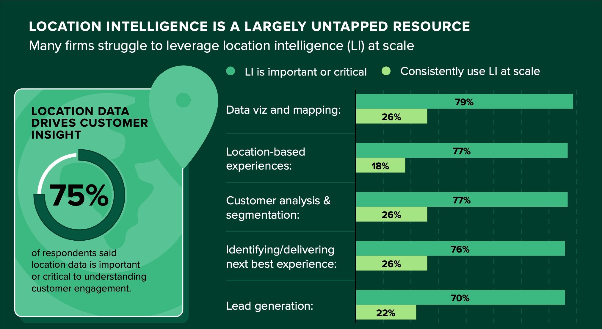
There’s no denying retail is a location-driven business, and location data is critical to understanding and serving customers. According to a 2022 Forrester and Esri survey, 75% of respondents said location is important or critical to understanding customer engagement. They also found that while it’s key to sustainable growth, location data is an untapped resource for many retailers, as inadequate skills and technical capabilities prevent most from using location data to its full potential.

Source: Forrester and Esri
Leading retailers use store mapping and location analytics to gain the context they need to drive efficiencies and sales. Some even have teams dedicated to analyzing and monitoring location data. Geographic information system (GIS) analysis gives them strategic insights to visualize and understand the market. It can help them understand customer behavior, understand the competition, determine where to grow their business, and visualize and manage operations. Every person in the modern world has used a GIS—they just may not know it. If you use Google Maps to get around and have searched “coffee shops near me” while driving somewhere unfamiliar, you’ve used a GIS.
For retailers, GIS links information to location to offer an aerial, integrated view of everything that’s happening in a market at a hyper-local level. It’s a visual representation of layers of information that allows you to surface data you couldn’t otherwise see, uncover patterns, pinpoint explanations behind the data, and glean fresh insights that can help you reduce costs and risks and make better-informed decisions for your business.
4 Use Cases for Retail Location Analysis
Retailers and brands can use GIS mapping to solve nearly every retail dilemma they face. From deciding optimal locations to open new stores to deciphering why high-potential stores or product placements are underperforming, the possibilities are proverbially endless.
1 | Understand customer behavior
Location intelligence combines demographic and location data (such as store accessibility, socioeconomics, and other demographic information) to portray your target customers’ appetite for your store or product, their buying behaviors, and their priorities. Use these insights to engage them in the right way, at the right time, with the right products. And use them to manage your teams, assets, and inventory to meet their changing demands.
2 | Understand the competition
Knowing where your competitors are related to your location and how they’re performing gives you an understanding of whether they’ve failed to meet customer needs or demands or left unrealized opportunities on the table. Just because a competitor is nearby doesn’t mean there isn’t room for a new entrant. Sometimes, you can benefit from locating next to your competitors because customers may visit multiple stores in one visit.
3 | Where to grow your business
When you’re ready to explore new market opportunities or open new stores, GIS gives you an accurate, hyper-local, holistic view of the market so you can identify the markets with the most potential customers and pinpoint locations that are most likely to perform. Does the store you want to occupy need renovation? How accessible is the store for your target customers? How close is it to your other locations? Are there competitors in the area? If so, how close are they to this location? Are they leaving market opportunities on the table you can tap into? What are the drive time, walking distance, distance from public transportation, and traffic flow patterns, and how do they impact this location?
4 | Visualize and manage operations
From gauging in-store foot traffic, to identifying the best zip codes to post job openings, to optimizing reps’ territories, to managing inventory, to adapting to supply chain challenges, GIS can help you visualize and manage your retail operations. You can learn when people are visiting your store, who’s visiting, how far they drove, and which other stores they visited. You can also identify which stores require the most coverage to win the most potential customers based upon your target customers’ demographic profile and staff accordingly. You can also analyze sales performance at all your locations. You can learn why high-potential stores have low performance. Is it because competitors are nearby? Or are your highest-performing stores absorbing customers from other locations?

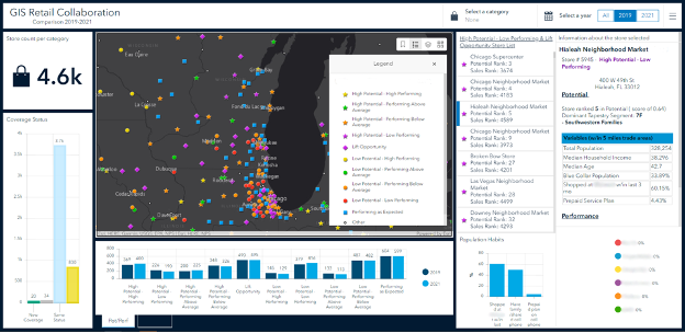
This sample dashboard shows how a brand or retailer can use GIS to assess how a store is performing compared to its potential, linking visual insights to data to make better-informed decisions.
GIS also enables:
- Market intelligence and planning: Precise insights to inform strategies in merchandising, marketing, pricing, and customer engagement
- Location planning and optimization: Model and evaluate site strategies through visualization of demographics, competition, traffic and migration patterns, and more
- Trade area optimization: Ensure equitable opportunity for virtual and in-person sales teams by defining, analyzing, and optimizing trade areas and sales territories
- Route planning: Decision support for calculated arrival times and route efficiencies
- Customer insights: Understand customer behavior by connecting people, locations, and data to create authentic engagement strategies and personalized experiences
- Performance optimization: Forecast and improve performance by understanding retail store potential based on customer profiles, competitive presence, and more
- Risk reduction: Understand sources of risk and predict scenario-based outcomes from supply chain disruptions to natural disasters
- Merchandizing planning: Understand the relationship between in-store and ecommerce sales to strengthen omnichannel sales and maximize the halo effect of brick-and-mortar
- Cannibalization mitigation: Map in-store movement patterns and point-of-sale data to optimize merchandise placement and assortment
The Difference GIS Mapping Makes
It’s unwise to make strategic decisions from snippets of information. Think of the blind men and the elephant analogy. All perspectives are individually accurate, but they’re only broadly accurate and useful when combined and applied as a whole.
What’s the demographic profile of consumers who live in the area? What socioeconomic factors influence their spending habits? Who and where are the local competitors? What’s the drive time, walking distance, and distance from public transport to the store? What traffic flow patterns are impacting store traffic? Which store locations represent unrealized opportunities that nearby competitors don’t cover?
GIS mapping can answer these questions and so much more. Beyond one-dimensional data from a database or spreadsheet, GIS mapping tells a story that emerges from analyzing layers of information to paint an integrated, strategic, actionable picture.
Ready to talk?
You can find our analysts at the intersection of location intelligence and retail expertise, ready to put the power of GIS to work for you.


